

Open User Map
Open User Map is an interactive WordPress plugin that lets your visitors contribute locations, routes, and areas to a customizable map with easy.
About Open User Map
Open User Map is a powerful and intuitive interactive maps plugin for WordPress that fundamentally changes how website owners can engage with their audience through location-based content. At its core, this tool allows any website visitor to contribute locations directly to a map through a simple frontend interface, creating a dynamic and ever-evolving resource that grows with community participation. The platform is designed for accessibility and ease of use, requiring absolutely no coding knowledge, no Google Maps API key, and no complex setup procedures to get started. Whether you are running a local business directory, a community events calendar, a tourism guide, a real estate listing site, or an interactive campus map, Open User Map provides the infrastructure to collect, manage, and display location data with complete control. The plugin offers a comprehensive approval workflow system, ensuring that all user-submitted content is reviewed before becoming publicly visible, maintaining quality and accuracy. With over 15,000 active installs, a perfect 100 percent five-star rating, and recognition as the number two map plugin on WordPress.org, Open User Map has established itself as a trusted and reliable solution for website owners worldwide. The platform is built for versatility, supporting traditional map layers, custom image maps for floor plans or event layouts, and advanced filtering interfaces that transform raw location data into an organized, searchable, and visually appealing experience for end users.
Features of Open User Map
Frontend Location Submissions and Editing
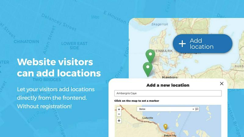
Enable your website visitors to add and edit locations directly on your map through an intuitive frontend interface. Clicking the Add location button allows users to place a marker, submit detailed information, and upload relevant media, with all submissions pending your approval before going live. The editing capability extends to existing locations, allowing users to update their own contributions, ensuring the map always reflects the most current and accurate information without manual intervention from site administrators.
Lines and Areas for Routes and Zones
Go beyond simple point markers by adding routes, paths, zones, and regions directly to your map with the Lines and Areas feature. This functionality allows you to highlight trails, service areas, event grounds, neighborhoods, construction zones, or any custom shape that helps visitors understand spatial relationships at a glance. Distances and area sizes are calculated automatically, providing helpful measurements for routes and polygons right out of the box, making this feature invaluable for outdoor recreation sites, urban planning projects, and event management.
Custom Image as Map
Upload any image and transform it into a fully interactive map, whether it is an overlay, floor plan, event layout, game map, product diagram, campus guide, or seating chart. Users can place markers directly on top of the image with the same powerful functionality as a traditional map, including adding locations, displaying custom fields, enabling filtering, and creating an engaging, clickable experience tailored exactly to your specific use case. This feature opens up endless possibilities for non-geographic mapping applications.
Advanced Filter Interface
Create a filter sidebar that appears next to your map, allowing visitors to filter locations by any custom field you have configured. This powerful interface gives users a clearer, more intuitive way to explore your mapped data by narrowing down results based on specific criteria. You can also add custom HTML content sections within the filter sidebar to display additional information or branding, effectively creating a comprehensive search and discovery tool that enhances user experience and engagement with your location data.
Use Cases of Open User Map
Community-Driven Local Business Directory
Create a comprehensive local business directory where community members can add their favorite restaurants, shops, and services directly to a shared map. Business owners can submit their locations with detailed information including hours of operation, contact details, and photos, while administrators maintain quality control through the approval workflow. Visitors can then filter businesses by category, read reviews, and use the star rating system to identify the best places in town, creating an organic, community-maintained resource that stays current without constant administrative updates.
Interactive Campus and Event Mapping
Universities, conference organizers, and festival planners can deploy Open User Map to create detailed interactive maps of their venues. Using the Custom Image as Map feature, you can upload floor plans or site layouts and allow attendees to mark points of interest such as restrooms, food vendors, information booths, and session rooms. The Lines and Areas feature can highlight walking paths, security zones, and restricted areas, while the approval workflow ensures that only authorized users can make official updates to the map during the event.
Tourism and Travel Guide Platform
Build a comprehensive tourism website where travelers and locals alike can contribute points of interest, hiking trails, scenic viewpoints, and hidden gems within a region. The Lines and Areas feature is particularly useful for marking hiking routes, bike paths, and scenic drives with automatic distance calculations. Visitors can upvote their favorite locations, helping the community surface the best attractions, while the custom fields allow for detailed descriptions, seasonal availability, and accessibility information that enriches the travel planning experience.
Real Estate and Property Listings
Real estate agencies and property managers can use Open User Map to create an interactive property listing map where agents can add available properties with detailed custom fields for price, square footage, number of bedrooms, and property type. The advanced filter interface allows potential buyers to narrow down properties based on their specific criteria, while the Lines and Areas feature can highlight school districts, neighborhood boundaries, and flood zones. The approval workflow ensures that only authorized agents can list properties, maintaining data integrity and professionalism.
Frequently Asked Questions
Do I need a Google Maps API key to use Open User Map?
No, you do not need a Google Maps API key to use Open User Map. The plugin is designed to work without any external API keys or complex setup procedures. This eliminates the common headaches associated with API key management, billing concerns, and usage limits that often come with Google Maps integration. You can simply install the plugin and start creating your interactive map immediately.
Can I control which user-submitted locations become visible on the map?
Yes, Open User Map includes a comprehensive approval workflow system that gives you complete control over all user-submitted content. When a visitor adds or edits a location, it is placed in a pending state and will not appear on the public map until you review and approve it. This ensures that all location data meets your quality standards, prevents spam or inappropriate content, and maintains the accuracy and reliability of your map.
Is Open User Map compatible with any WordPress theme?
Open User Map is designed to be fully compatible with virtually any WordPress theme. The plugin integrates seamlessly into your existing site structure and does not require any specific theme or template modifications to function correctly. It works with both classic and block-based themes, and the map can be embedded into any page, post, or widget area using a simple shortcode or block.
What happens after the 7-day free trial of the PRO version ends?
The 7-day free trial of Open User Map PRO is designed to be completely risk-free and hassle-free. After the trial period ends, it does not automatically convert into a paid subscription. You will not be charged anything, and the trial simply expires. You can then choose to purchase the PRO version if you wish to continue using the advanced features, or you can revert to the free version which still offers powerful core functionality for your mapping needs.
Pricing of Open User Map
Open User Map offers a free version available for download on WordPress.org that includes core mapping functionality, frontend submissions, and basic approval workflows. For users who need advanced features such as Lines and Areas, Custom Image as Map, Advanced Filter Interface, Upvotes and Likes, Star Ratings, Opening Hours display, and Regions functionality, the PRO version is available. A 7-day free trial of the PRO version is offered with no credit card required and no automatic conversion to a paid subscription. Specific pricing details for the PRO version should be confirmed on the official Open User Map website.
Similar to Open User Map

Built2Win AI Indexing
AI‑ready websites, WebAgentScan SaaS, and Indexing Pack. MCP, A2A, llms.txt — hand‑coded PHP, complete ownership, flat‑fee, free quote.

Insta Bio
InstaBio is a free Instagram bio generator offering stylish Unicode fonts, attitude lines, and Hindi devotional bios (Radhe Krishna, Mahadev).

Webleadr
Webleadr helps you effortlessly find and contact web design leads, including businesses without websites, in just a few clicks.

Idearium
Idearium crafts impactful websites and digital experiences that drive growth and capture attention for your business.

FilexHost
FilexHost instantly creates shareable web pages from any file you upload.

Crawlkit
CrawlKit is an API-first web scraping platform that effortlessly extracts structured data from any website with a.

Best Boilerplates
Best Boilerplates helps you compare and choose the perfect SaaS starter kit to launch your app faster.

Shadcn UI Kit
The Shadcn UI Kit provides a complete library of production-ready components and templates to accelerate modern web.